
")
")
")
")
")
")
great circle sailing - nautical calculator of routes and distances
great circle navigation and rhumb line - how to calculate distance and course (bearing) between two points - marine great circle formulas - navigation calculator
Formulas, programs and calculations to obtain distance and course (bearing) - loxodromic distances (rhumb line) and orthodromic waypoints (great circle sailing) - orthodromic and loxodromic navigation calculator - two spreadsheet excel files - (free download and use!)
distance and course (bearing) between Vigo and Boston .........
great circle sailing (orthodromy) or rhumb line (loxodromic route) ?
1st file - a full version of Great Circle Sailing - Rhumb Line - Waypoints ( full track ) - Route Graph
A full program for all users (students, sailors, officers and masters of the "merchant navy " .... ) : courses, distances (rhumb line & great circle sailing), orthodromic data ( vertex coordinates ), E.T.A. (estimated time of arrival), compass direction, manual-automatic waypoints calculator and planning routes.
This file is created thanks to the remarkable ability of Mr. Jelle Schaap in the development of excel programs. It is a logical evolution and completion of the second file. This feature distinguishes the file from many others currently on the web. The program allows the user to customize all navigation data; 60 waypoints (great circle navigation) and 60 rhumb lines can be managed. Instructions are included in the file.

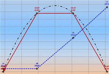
Sheet "Chart1" shows a diagram with the location of some parameters: great circle navigation, rhumb lines, courses, waypoints:
 |
It's essential to enable macros before using the program (calculations are not performed without activating the macro, however, see the instructions in the file). Files include translations in languages (English, German, Dutch, Spanish and Italian).
| DOWNLOAD |
2nd file - Great Circle Sailing - Rhumb Line - (small program)
This simple file provides the following information (navigation data) only : course, distances in nautical miles (great circle and rhumb line), initial course and vertex latitude
a view of the spreadsheet (excel file) :

Coordinates must be entered : latitudes and longitudes (degrees- minutes-seconds) "n" for north latitude, "s" for south latitude, "w" for west longitude, "e" for east longitude.
| DOWNLOAD |
Formulas
calculation for incr. latitude
formula : ( 7915,7 * log tan (45° + lat/2)) - (3437,7 * e*e * sine lat)
course (c.) or (bearing) rhumb
formula : tang. c. = longitude difference/increased latitude difference
loxodromic distance (rhumb line)
c. < 45° = latititude diff. * sec c.
45° < c. < 87° = latititude diff. * tg c. * cosec c.
c. > 87° = longitude diff. * cos med.lat. * cosec c.
excel will use the best formula according to the value of the course (0°-90°)
orthodromic distance (gc great circle)
formula : cos gc = (sine lat a * sine lat b) + (cos lat a * cos lat b * cos longitude diff.)
init. course (oc great circle)
formula : ctg oc * sec lat.a = cosec long.diff. * tan lat.b - cot long.diff. * tan lat.a
vertex latitude
formula : cos hl = cos lat a * sine oc
© 2006-2024 - all rights reserved www.nauticalalmanac.it