
")
")
")
")
")
")

star finder for celestial navigation
Sun and stars position in the sky
Stars identifier (marine stars searcher) - Day and night sky (skymap) in an "excel" planisphere (.xls/.xlbs) with animation
an important manual tool for planning stars and Sun sights !
It allows to identify the brightest stars and to predict the position in the sky of the nautical stars not yet visible. It's fundamental to sight the celestial bodies with a clear horizon. At the beginning of the nautical twilight, the stars cannot be seen by the naked eyebut only with the telescope of the sextant. To do that the altitude set on the sextant (Dead Reckoning Altitude) must have a maximum approximation of one degree.
Seamen used various traditional star-finders and spheroscopes in the past; nowadays few types of this tool are produced. Model 2102-D is the most important star-finder (two main plastic plates - eight plates for latitude North/South : 5°, 15°, 25°, 35°, 45°, 55°, 65°, 75°, 85° - size 12” diameter ). The number of the plates (8) is insufficient; the interval of latitude between two plates should be reduced from 10 degrees to 5 degrees. Now it can happen that the observer in latitude 40° North has to use the plate for 45° or 35°. The approximation of the altitude to be set on the sextant can reach five degrees. Sometimes the stars are really hard to find !
It solves this problem ensuring precision of 0,1 arcminute. Using this tool (freeware) the observer is sure to quickly find the stars (weather permitting).
The stellar planisphere in an excel file was created for Office 97-2003 (.xls) and for Office 2007 in a "binary" format (.xlsb) so the program can only be used with Office 2007 (or later) installed; It is essential to enable macros before using the program (calculations and animation are not performed without activating the macro, see the instructions sheet “ Caution ”).
Description
File consists of four sheets :
Setting Sheet
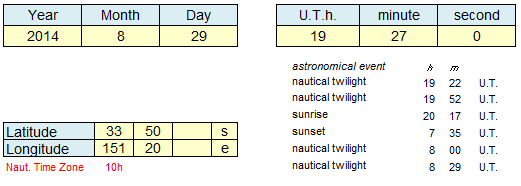
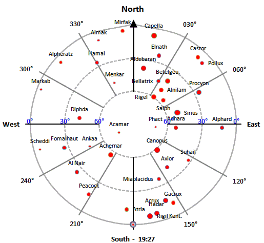
In this sheet the user has to enter these data: year, month, day - hours, minutes and seconds in U.T. – (Greenwich Mean Time) – latitude and longitude. The sheet ( printable as a A4 format) portrays all astronomical/nautical events and the following data for sixty-six nautical stars (Sun included) : apparent magnitude, precise altitude above the horizon and azimuth.
Chart1
The sky map (an indispensable tool) allows the user to plan the star sight: fast choosing and optimizing.
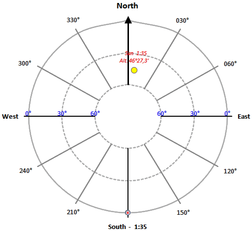
StartMap
The software shows the animation of the stars in the sky - day and night; during the animation times are expressed in the time of the Time Zone.
Caution
Instructions are provided to enable the macros activation and resize the maps.
| Download |
Endless thanks and gratitude to the creativeness of Mr. Jelle Schaap ( author of the sky-maps )
© nauticalalmanac 2024 - all rights reserved